Import Polygons from a Shapefile
This guide provides step-by-step instructions on how to import polygons in shapefile format to be used in SAInt as a visualization aid for geographical areas or support for "Subsystems", "Zones" and "Groups". The same method applies to all energy networks (electric, gas, thermal, etc.).
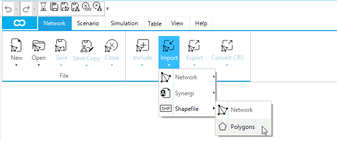
1. Importing polygons from a shapefile
Start the import procedure with (Figure 1). SAInt prompts for the location of the file in shapefile format to be used (i.e., the *.shp file), and, after the selection, it asks for the name and location where to save the resulting *.plg file. A message informs the user of the outcome of the import. When successful, a pop-up reports the path of the newly written SAInt polygon file (Figure 2). Otherwise, a more informative error message is provided. Please, note that SAInt focuses the import on catching the geometry of polygons. Polygons' attributes in the *.dbf file of the shapefile are simply merged as an alphanumeric string and associated with the Info property of the polygon. It is recommended to simplify the *.dbf file so that only one or two fields are available. Finally, remember to check that the units of measure for XY-Coordinates in are matching the units used in the shapefile containing the data.
|
SAInt can only accept valid polygons 2D files. Other geometry types will result in an error message. |
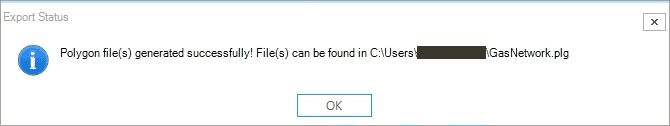
GasNetwork.plg file.|
SAInt does not try to simplify the geometry of the imported polygons. Shapes with lots of vertices may result in a decreased responsiveness of the map window, when polygons are visible. |
2. Where polygons are saved
Polygons are saved in a dedicated file with the extension *.plg. This file is created by default in the project directory. When polygons are imported from a shapefile, the user is requested to specify a *.plg file. SAInt will save the polygons in the file specified, but it will also append the polygons in the *.plg file of the active project. To avoid having two copies of the same polygons in different files, the user can specify as the destination of the import procedure the *.plg of the active project, overwriting it if already present.
|
To use polygons created in a different project, the easiest way is to use the procedure . Geometry, attributes and graphical properties will be transferred in the new project. |