Import data with a Coordinate Reference System
This guide provides step-by-step instructions on how to import network data using a supported coordinate reference system (CRS) into SAInt-GUI. Refer to the section "Coordinate Reference Systems" or the sheet "CRSINFO" in the import network template in Excel format for a list of supported systems.
We describe the procedure using a simple gas system and an Excel import template. However, the same method applies to all energy network types, supported template formats, and any valid coordinate system.
1. Prepare your geographic data
The first step is to identify which coordinate reference system the data uses. If the data are extracted from a "geographic information system" (GIS), it is quite easy to identify or set the CRS to meet any specific needs. Software like Qgis or Arcgis(c) by ESRI can easily convert between CRS.
Once the CRS is identified, it is necessary to retrieve the associated EPSG code either from the list of the supported systems or from an on-line database like epsg.io.
If the used coordinate reference system is not among the ones supported by SAInt, the user needs to convert the data. We advise using either the projected system "WGS 84 / Pseudo-Mercator" (EPSG_3857
`) or the geographic "WGS 84" (EPSG code 4326 and SAInt code `DEFAULT) coordinate reference system.
2. Prepare your import template
The second step is to transfer the data into an import template, preferably in Excel format, and define the coordinate reference system.
Let’s start by defining the CRS. In the network sheet of the Excel template, specify the value of the field CRSType. The default code value is NONE, which implies that the data will be imported in a Cartesian map view. The code value DEFAULT indicates the CRS with EPSG code 4326 (i.e., geographic latitude and longitude using the WGS84 datum).
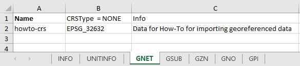
Figure 1 shows an example where coordinates are expressed using the system "UTM zone 32 N with datum WGS84" (EPSG code 32632).
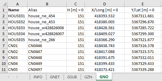
Once the CRS is defined, it is necessary to specify the location values of all node objects in the model. Figure 2 shows an example of the GNO sheet for a gas test network. Here, the coordinates are based on the CRS specified in the CRSType field. We recommend setting the correct unit of measure for the coordinates (i.e., meter for projected systems and degree with the symbol "-" for geographic systems).
SAInt does not support CRS for elevation.
|
Whenever the user is selecting a geographic coordinate reference system, SAInt will interpret coordinates as degrees in decimal format (i.e., 25.5° is 25° and 30'). For a projected coordinate reference system, SAInt will use meters as reference unit, even if the units in square brackets is different. When |
3. Import the data
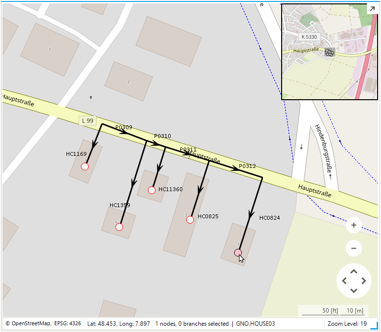
The last step is to import the data using from the tab "Network" of the ribbon bar. SAInt will recognize the CRS specified as one of the supported and perform a coordinate conversion to EPSG:4326. Figure 3 shows the test gas network on a base map. Note that the CRS is displayed on the bottom-left corner of the map view, next to the name of the map service provider (i.e., OpenStreetMap). The coordinates are reported as latitude (i.e., Y-axis) longitude (X-axis) for the node GNO.HOUSE03.